Ah.. la pluie est vraiment insupportable...
Quand il fait humide et qu'il pleut, je me sens tellement déprimé...
De plus, des pluies torrentielles sporadiques... c'est vraiment effrayant... ㅠㅠ
Il y a aussi un typhon qui arrive ici... et la fin de la saison des pluies est incertaine...
Je me sens vraiment comme si j'étais en Asie du Sud-Est... ouf...
------------------------------------------------------
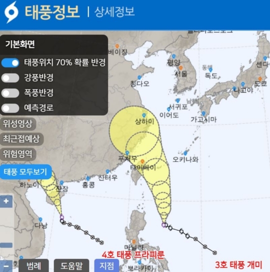
Le typhon numéro 3, le typhon Gaemi, se dirige vers le sud-est de la Chine.
La ligne de convergence stationnaire, qui pousse la haute pression du Pacifique Nord et apporte de fortes pluies de mousson, monte également vers le nord.
Selon l'Agence météorologique le 21, un système de basse pression tropicale de type 6 s'est développé en tant que typhon numéro 3, à environ 770 km à l'est de Manille, aux Philippines, vers 15 heures la veille.
Le typhon se déplace actuellement vers le nord-nord-ouest en mer, au nord-est de Manille.
Les agences météorologiques concernées par les typhons dans le nord-ouest du Pacifique, notamment en Corée, au Japon et aux États-Unis, s'attendent toutes à ce que le typhon traverse la mer à l'est de Taïwan pour atterrir du côté de Shanghai en Chine.
Selon le trajet prévu actuellement, le typhon n'affectera pas directement notre pays, mais il se déplacera vers le nord, renforçant ainsi la force de la haute pression du Pacifique Nord située au nord et provoquant son extension vers le nord.
L'anticyclone du Nord-Pacifique devrait s'étendre vers le nord à partir du 22. À ce moment-là, une dépression atmosphérique traversant la haute atmosphère du côté nord de la Corée réactivera la zone de nuages de pluie, entraînant des précipitations dans la région centrale, principalement sur la côte ouest de Gyeonggi, à partir de la matinée du 22.
Après le passage de la dépression le 23, de l'air sec descendra par l'arrière, provoquant des précipitations principalement dans la région nord de Gyeonggi.
Par la suite, le typhon continuera de se déplacer vers le nord-ouest, ce qui entraînera également une progression continue de la haute pression du Pacifique Nord, et il est prévu qu'une ligne de convergence stationnaire traversera la Corée du Nord vers le 25.
Ainsi, du 25 au 26, la mousson sera globalement en pause à l'échelle nationale, mais il faut encore attendre un peu pour déterminer si cette période marque la fin de la mousson estivale cette année.
Après le passage du typhon autour de la péninsule coréenne, le processus de réorganisation de la carte barométrique entraîne le retour de la ligne de front stationnaire vers le sud, ce qui pourrait provoquer des précipitations dans la région centrale.
La rapidité avec laquelle la haute pression du Pacifique Nord repoussée par le typhon récupère sa zone est une variable ; si elle récupère rapidement sa zone, la ligne de front stagnante restera positionnée du côté nord de la Corée, mais si elle revient lentement, la ligne de front pourrait descendre plus au sud que prévu.